
Natisinahikaniwoc:Grande-Vallée.jpg

E irikweckwemakisitc800 x 533 pixels Kotak erikokowactepiriki: 320 x 213 pixels | 640 x 427 pixels | 1 024 x 683 pixels | 1 280 x 853 pixels | 2 560 x 1 706 pixels | 4 301 x 2 867 pixels.
E otciparik masinahikaniwoc (4 301x2 867pixels, e irikweckamikak mawtockwemikan:12,16 Mionohwe MIME:image/jpeg)
Nosem
| E witcikemakak |
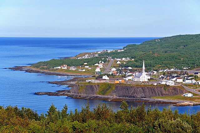
English: Grande-Vallée is a village situated halfway between Sainte-Anne-des-Monts and Gaspé, on the northern shore of the Gaspésie peninsula. It is one of the four villages forming the sector commonly known as « l'Estran ».
It owes its name to the passing of an immense glacier many thousands of years ago. This glacier's passage left an indelible mark, in the form of a valley, amongst the robust Appalachian Mountains. Here, the mountains literally embrace the sea while the river marries its waters with her own.
Français : Grande-Vallée est un village situé à mi-chemin entre Sainte-Anne-des-Monts et Gaspé, sur la côte nord de la péninsule de la Gaspésie.Il fait partie d'un petit groupe de quatre villages constituant un secteur surnommé l'Estran.
Il doit son nom à la vallée creusée il y a des milliers d'années par le passage d'un immense glacier en travers de la chaîne de montagnes des Appalaches. En ces lieux les montagnes embrassent la mer alors que la rivière y marie ses eaux. |
| Apitc | |
| Ite wetciparik |
|
| Ka ki masihiketc | Dennis Jarvis from Halifax, Canada |
| Lieu de la prise de vue | | Voir cet endroit et d’autres images sur : OpenStreetMap |
|---|
Orocowatcikan
Ce fichier est disponible selon les termes de la licence Creative Commons Attribution – Partage dans les Mêmes Conditions 2.0 Générique
- Kir ka wi totaman:
- matanowe – tapasiniha,matanowe minawatc koski miriwe nohwe matcewin
- nanto tota – nanto meckotina matci ohwe otamirowin
- Ke nanakatcitain naheritamowin:
- ka ki wectatc – Patoc mia ki ka itasinahwaw ka itasinahotisotc nohwe ka ki ocitat ohweriw kekotc ma nohwe ka miwotatc masinihikaniw matci kata pakitanak ( nama nohwe ki ka apitcitan naheritamowin kekotc ma e ici wawitamaskw ke totaman.)
- Matonowesinaha – Kecpin e meckotcitaiin kekocic wiec e ki ici keskinawapataman ka ki itasinatekipan patam ki ka masinahen ite ka ki otcipataman kekotc ka ki otciparik kitci pakitinikatek kitci actakaniwok.
| Cette image, qui provient de Flickr, a été vérifiée le March 13, 2012 par l'administrateur ou l'utilisateur de confiance (trusted user) File Upload Bot (Magnus Manske), qui a confirmé qu'à cette date, elle était publiée sur Flickr sous cette licence. |
E itatisokemakak masinahikaniwoc
Ota ici nta makona e tatokonikisitc acitc e tato tipahikaneak kitci wapataman apitc ka masinatek.
| E tatokonakisitc acitc e tato tipahikaneak | Masinasowinicic | E iskwaki | Ka mitatc | E iteritaman | |
|---|---|---|---|---|---|
| mekwatc | 13 Nikikw pisimw 2012 à 08:43 | | 4 301 × 2 867 (12,16 Mio) | File Upload Bot (Magnus Manske) | {{Information |Description=PLEASE, no multi invitations in your comments. DO NOT FEEL YOU HAVE TO COMMENT.Thanks. DO NOT SEND ME E-MAIL REQUESTING ME TO LOOK AT A PICTURE, I RETURN ALL COMMENTS IF YOU COMMENT. This is where I stopped for the night, ar... |
Ke irapatak masinahikaniwoc
minawatc ka apatak paskickwemakan nohwe mawtockwemakan :
Kitciwe e irapatak masinahikaniwoc
Kotakahik wikis apatcitawok ohweriw ka masinaterik:
- Ote ici apatan ar.wikipedia.org
- Ote ici apatan arz.wikipedia.org
- Ote ici apatan en.wikipedia.org
- Ote ici apatan eu.wikipedia.org
- Ote ici apatan fr.wikipedia.org
- Ote ici apatan fr.wikivoyage.org
- Ote ici apatan it.wikipedia.org
- Ote ici apatan ru.wikivoyage.org
- Ote ici apatan sv.wikipedia.org
- Ote ici apatan www.wikidata.org